
Monday, February 28, 2011
Severe Weather Update- Starkville, MS

Severe Weather- Starkville, MS


Forecast for Starkville, MS and Leesburg, VA

Starkville, MS
Overnight- Mostly cloudy, mild, and breezy. Winds gusting up to 30 MPH. Low temperature around 70.
Monday- Cloudy during the morning, with showers and thunderstorms likely by 1PM. Some storms could be severe with damaging winds to 60 MPH and heavy rain. Showers will continue through most of the afternoon, with some clearing by sunset. High temperature around 76.
Monday night- Mostly clear and cooler. Breezy with winds gusting up to 30 MPH. Low temperature around 37.
Tuesday- Sunny and warm. High temperature around 66.
Tuesday night- Clear with a low temperature around 38.
Wednesday- Sunny and warmer with a high temperature around 75.
Wednesday night- Clear and not as cold. Low temperature around 46.
Thursday- Sunny and warm with a high temperature around 77.
NEW! EXTENDED FORECAST- Mild conditions will continue through Saturday when the next storm system will bring showers and thunderstorms. Temperatures will be in the lower 70s Friday and Saturday, before becoming clear and cool Sunday with high temperatures in the lower to mid 50s.

Leesburg, VA
Overnight- Cloudy with occasional showers overnight. Low temperature around 43.
Monday- Mostly cloudy, breezy, and warm with showers and thunderstorms developing during the afternoon. Some of the storms could be strong to severe with damaging wind gusts to 60 MPH and heavy rain. Expect thunderstorms to move through during the late afternoon and evening. Winds gusting up to 30 MPH. High temperature around 70.
Monday night- Showers and thunderstorms during the evening, some strong, ending around 10PM. Continued breezy with winds gusting to 30 MPH. Expect partial clearing late overnight. Low temperature around 34.
Tuesday- Sunny and cooler with a high temperature around 50.
Tuesday night- Mostly clear with a low temperature around 32.
Wednesday- Sunny and warmer with a high temperature around 58.
Wednesday night- Mostly clear and cold with a low temperature around 28.
Thursday- Mostly sunny with a high temperature around 46.
NEW! EXTENDED FORECAST- Expect temperatures around 50 Friday with clear skies. Showers and thunderstorms will likely return Saturday ahead of another storm system with high temperatures around 60. As the cold front moves through Saturday night, expect cooler conditions and partial clearing late Sunday night with highs in the upper 40s.
Saturday, February 26, 2011
Forecast for Starkville, MS and Leesburg, VA
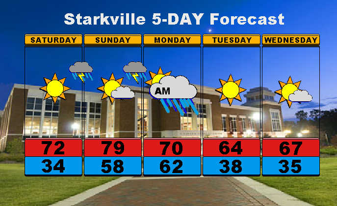
Starkville, MS
Overnight- Clear and chilly. Low temperature around 34.
Saturday- Sunny and warm. High temperature around 72.
Saturday night- Clear, with a chance of showers and thunderstorms overnight. Low temperature around 58.
Sunday- Sunny and breezy with a few clouds during the afternoon. Winds gusting up to 30 MPH. Scattered showers and thunderstorms developing by 5PM. High temperature around 79.
Sunday night- Showers and thunderstorms likely overnight. Breezy with winds gusting up to 30 MPH, and higher in thunderstorms. Low temperature around 62.
Monday- Showers likely during the morning, with clearing toward the afternoon. Breezy with winds gusting up to 30 MPH. High temperature around 70.
Monday night- Mostly clear and chilly with a low temperature around 38.
Tuesday- Sunny and cooler. High temperature around 64.
NEW! EXTENDED FORECAST- Expect clear conditions to continue through Friday, with temperatures warming up to the mid to upper 60s.
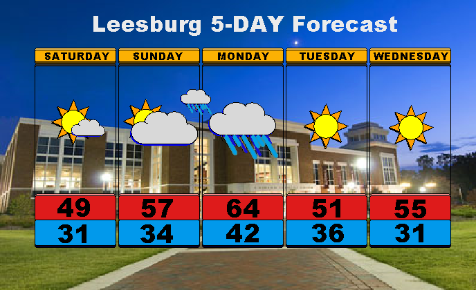
Leesburg, VA
Overnight- Clear with a low temperature around 31.
Saturday- Mostly sunny, with a few clouds in the afternoon. High temperature around 49.
Saturday night- Clear with a few clouds overnight. Low temperature around 34.
Sunday- Increasing clouds throughout the afternoon. Warmer with a high temperature around 57.
Sunday night- Cloudy with showers developing by 10PM. Low temperature around 42.
Monday- Rain likely for most of the day. Mild with a high temperature around 64.
Monday night- Showers likely during the evening, ending by 9PM. Colder with a low temperature around 36.
Tuesday- Sunny with a high temperature around 51.
NEW! EXTENDED FORECAST- Expect clear conditions to continue through Friday, with temperatures in the lower 50s Wednesday, upper 40s Thursday, and around 50 Friday.
Friday, February 25, 2011
Forecast for Starkville, MS and Leesburg, VA

Starkville, MS
Overnight- Expect light rain and drizzle to end by 3AM. Remaining cloudy overnight. Low temperature around 55.
Friday- Mostly cloudy during the morning, with clearing during the afternoon. High temperature around 60.
Friday night- Clear and cold. Low temperature around 35.
Saturday- Sunny and warm. High temperature around 71.
Saturday night- Increasing clouds overnight, with showers possible after 2AM. Low temperature around 54.
Sunday- Mostly cloudy and windy, with thunderstorms likely during the afternoon. High temperature around 77.
Sunday night- Showers and thunderstorms during the evening, ending overnight. Low temperature around 56.
Monday- Mostly sunny with a chance of showers and thunderstorms during the afternoon. High temperature around 72.
NEW! EXTENDED FORECAST- Expect clear skies and temperatures to drop slightly into the lower to mid 60s next week behind a cold front that will move through Sunday/Monday. High temperatures will likely be around 70 by Thursday.

Leesburg, VA
Overnight- Mostly cloudy with showers continuing overnight. Low temperature around 43.
Friday- Showers likely during the morning, then thunderstorms developing during the afternoon and evening. Expect windy conditions with winds gusting up to 60 MPH with additional thunderstorm wind gusts. High temperature around 63.
Friday night- Clearing and remaining breezy. Winds gusting up to 50 MPH. Low temperature around 25.
Saturday- Mostly sunny with a high temperature around 48.
Saturday night- Mostly clear with a low temperature around 30.
Sunday- Increasing clouds throughout the day. High temperature around 55.
Sunday night- Mostly cloudy with showers developing overnight. Low temperature around 41.
Monday- Cloudy with showers likely for most of the day. High temperature around 57.
NEW! EXTENDED FORECAST- Conditions will improve through the rest of next week as sunshine returns. However, temperatures will drop into the mid to upper 40s Tuesday, and back around 50 by Wednesday and Thursday.
Thursday, February 24, 2011
SEVERE WEATHER UPDATE- Starkville, MS


The entire area including north/central Mississippi and west/central Alabama are under a Tornado Watch until 2AM Friday morning. Be careful if you are going out later this evening and stay alert to changing weather and tornado sirens.
Severe Weather Update- Starkville, MS

Subscribe to:
Posts (Atom)