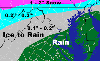
This is the current ice accumulation map for Leesburg. I've lowered the ice totals because I think warm air will move in quicker than I first thought. Snow/sleet will likely begin falling late Monday night into Tuesday morning when it will mix with and eventually turn to freezing rain. Freezing rain will continue through Tuesday morning before becoming all rain for the remainder of the day. Leesburg will likely see 0.1 to 0.2 inches of ice Tuesday morning, which will melt off by the afternoon as temperatures warm up and rain falls. Areas east of D.C. will see rain throughout the entire storm. Areas in the Appalachian mountains and to the west may see slightly higher amounts of ice (0.2 to 0.3 inches) before freezing rain becomes all rain. Snow will fall for most of the day in Pennsylvania but will eventually turn to rain late in the day. Areas in extreme northern Maryland and southern Pennsylvania may see 1 to 2 inches of snow. Rain will continue for most of the area overnight before ending midday Wednesday. I will update this map as the storm develops.

No comments:
Post a Comment