This is the current radar image. Blue/green is rain which is currently falling through most of Virginia. Snow (white/pink) is falling further west toward the mountains. As the precipitation moves in, temperatures will drop as colder air moves in from the northwest. When it does, rain will change to snow and fall heavy at times. There is a slight chance of "thundersnow" (lightning and thunder associated with snow, basically a thunderstorm of snow) with some of the heavier snow bands.
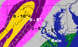
This is the forecast snow total map. I have kept Leesburg in 6 to 8 inches because the storm seems to be taking the same track as it was forecast to yesterday. Areas west of Leesburg, as close as Purcellville may see 8 to 10 inches of snow, however most 10+ inch accumulations will occur closer to Winchester along the Appalachian mountains. Areas east of Leesburg toward Sterling and Herndon will most likely see accumulations around 3 to 6 inches. Areas farther east of that will see lower accumulations (1 to 3 inches) due to a longer period of rain.
This is the current watch/warning map. Areas in pink are under a Winter Storm Warning until 4AM Thursday and will see snow totals of at least 5 inches. Counties in purple are under a Winter Weather Advisory where they will see lower amounts of snow, around 1 to 3 inches.


No comments:
Post a Comment