This is the current ice accumulation map. As of right now, it looks like we'll get about 1/4 inch of ice and up to 1/2 inch of snow here in Starkville. Precipitation will likely start around 4PM and continue overnight as freezing rain. Warmer air will move in around 2AM, causing freezing rain to transition to rain. There may be times where sleet and snow mix in, however for most of the night the precipitation will fall as freezing rain. The colorful line running through the middle of the map shows where I think the transition between most of the sleet/snow and freezing rain will be. Most of central and northern Mississippi will receive 1/4 inch of freezing rain, and up to 1 inch of snow. Areas to the south of Starkville will probably not see any snow or sleet, but may get as much as 1/2 inch of freezing rain.
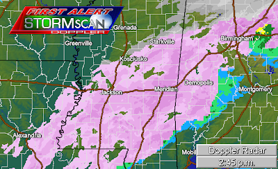
This is the current radar image. The pink colored reflectivity represents ice (sleet or freezing rain) where surface temperatures are above 32 degrees. Starkville is just on the fringe of the heavier precipitation. At around 2:30PM, I saw sleet and snow mixed lightly falling which has transitioned to light snow (2:45PM). Meridian and Lousiville have been reporting freezing rain for the past 2 hours. Precipitation will become heavier and more persistent as the evening goes on. Expect road conditions to deteriorate quickly.


No comments:
Post a Comment