This is the current radar image for the entire eastern U.S. There is currently a large line of thunderstorms extended from northern Ohio southwest through eastern Texas moving to the east. The red/purple reflectivity are the heaviest areas of rain and thunderstorms. The white bolts are lightning strikes and each pink box and red circle indicate a severe thunderstorm or an area of rotation. Expect this line to continue pushing east throughout the day Monday. Areas around Starkville will likely see these storms move through late morning Monday.
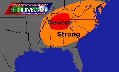
This is the current severe weather outlook for Monday. Most of Tennessee, northern Alabama, and southern Kentucky have the greatest risk for severe weather tomorrow. As the line of storms from the radar image pushes east Monday, daytime heating along with warm air already in place ahead of the front will help to strengthen these storms and cause new storms to develop. Areas highlighted in red have the highest chance of seeing tornadoes and strong winds gusting over 60 MPH. Anywhere else ahead of this line (areas highlighted in orange) has a chance of seeing severe weather tomorrow, however conditions will not be as favorable for a large severe weather outbreak.


No comments:
Post a Comment